I’ve had this in my bookmarks since back in late December and I’m finally getting around to it now. What is this map with seemingly random markers on it? It’s the locations of Pitt football’s away football games since 1998. MapGameDay.com posted maps for all of the FBS teams and made them sortable by teams and conferences. The Wizard of Odds then compiled all of the data and made fancy graphs from that.
According to this, the farthest we’ve traveled in each compass direction.
North: @ Syracuse (’98, ’00, ’02, ’04, ’06) in Syracuse, NY
South: @ Miami (’98, ’00, ’02) in Miami, FL
East: @ Boston College (’99, ’01, ’03) in Chestnut Hill, MA
West: @ Nebraska (’05) in Lincoln, NE
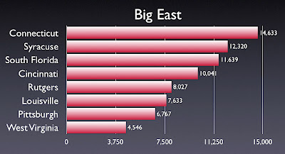
Our amount of travel compared to other Big East teams?

And as a whole, the Big East travels less than every other conference except the ACC and SEC. Of course, the fact we only have 8 teams in our conference might lead to that.
Just looking at it and clicking the markers, it’s easy to see all of their trips to the south have come only recently.
That’s an interesting bit of info. Having some bowls in the last three years would have changed it a little I suppose.
Another question: Does PITT charter flights for the team. I’m 6’6″ tall and hate flying and can’t imagine having to play a football game the day after I’ve been folded into an airplane seat for hours.
Don’t be cheap, purchase a 1st class ticket!
But the Big East plays the same number of games, so that shouldn’t matter.


